Scale: N/A Captain's Supplies is a Print-on-Demand nautical chart dealer for NGA Charts. Charts are printed on high-quality heavy paper with waterproof ink. Other options available. NGA charts are printed using the most recent data provided by the National Geospatial-Intelligence...
Scale: N/A Captain's Supplies is a Print-on-Demand nautical chart dealer for NGA Charts. Charts are printed on high-quality heavy paper with waterproof ink. Other options available. NGA charts are printed using the most recent data provided by the National Geospatial-Intelligence...
Scale: N/A Captain's Supplies is a Print-on-Demand nautical chart dealer for NGA Charts. Charts are printed on high-quality heavy paper with waterproof ink. Other options available. NGA charts are printed using the most recent data provided by the National Geospatial-Intelligence...
Scale: N/A Captain's Supplies is a Print-on-Demand nautical chart dealer for NGA Charts. Charts are printed on high-quality heavy paper with waterproof ink. Other options available. NGA charts are printed using the most recent data provided by the National Geospatial-Intelligence...
Scale: 1:500,574 Captain's Supplies is a Print-on-Demand nautical chart dealer for NGA Charts. Charts are printed on high-quality heavy paper with waterproof ink. Other options available. NGA charts are printed using the most recent data provided by the National Geospatial-Intelligence...
Scale: 1:500,000 Captain's Supplies is a Print-on-Demand nautical chart dealer for NGA Charts. Charts are printed on high-quality heavy paper with waterproof ink. Other options available. NGA charts are printed using the most recent data provided by the National Geospatial-Intelligence...
Scale: N/A Captain's Supplies is a Print-on-Demand nautical chart dealer for NGA Charts. Charts are printed on high-quality heavy paper with waterproof ink. Other options available. NGA charts are printed using the most recent data provided by the National Geospatial-Intelligence...
Scale: N/A Captain's Supplies is a Print-on-Demand nautical chart dealer for NGA Charts. Charts are printed on high-quality heavy paper with waterproof ink. Other options available. NGA charts are printed using the most recent data provided by the National Geospatial-Intelligence...
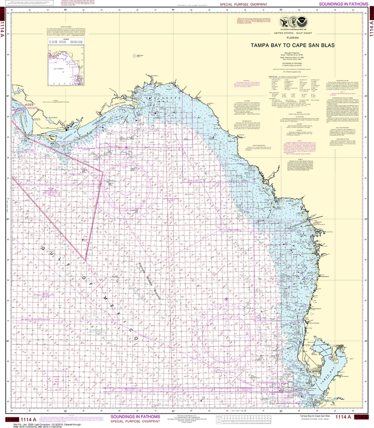
NOAA Chart 1114A: Tampa Bay to Cape San Blas (Oil and Gas Leasing Areas)
$23.75
The chart you are viewing is NOT updated weekly and does NOT include all the of the latest Notice to Mariners corrections. Region: Gulf Coast & Caribbean Islands Paper Size: 37" x 36" Chart Image Size: 33" x 29"...
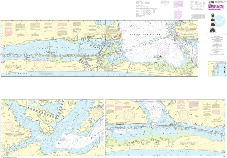
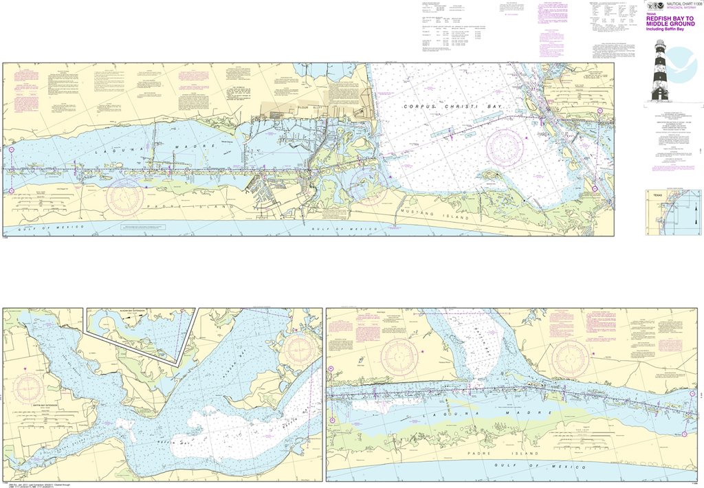
NOAA Chart 11308: Intracoastal Waterway - Redfish Bay to Middle Ground
$23.75
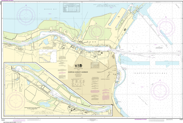
The chart you are viewing is NOT updated weekly and does NOT include all of the latest Notice to Mariners corrections. Region: Gulf Coast & Caribbean Islands Paper Size: 62" x 42" Chart Image Size: 41" x 59"...
The chart you are viewing is NOT updated weekly and does NOT include all of the latest Notice to Mariners corrections. Region: Gulf Coast & Caribbean Islands Paper Size: 56" x 36" Chart Image Size: 35" x 53" Scale:...
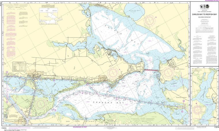
NOAA Chart 11314: Intracoastal Waterway - Carlos Bay to Redfish Bay-including Copano Bay
$23.75
Region: Gulf Coast & Caribbean Islands Paper Size: 54" x 36" Chart Image Size: 30" x 51" Scale: 1:40,000 Captain's Nautical Supplies is a Print-on-Demand nautical chart dealer for US Waters. All charts are printed up-to-date...
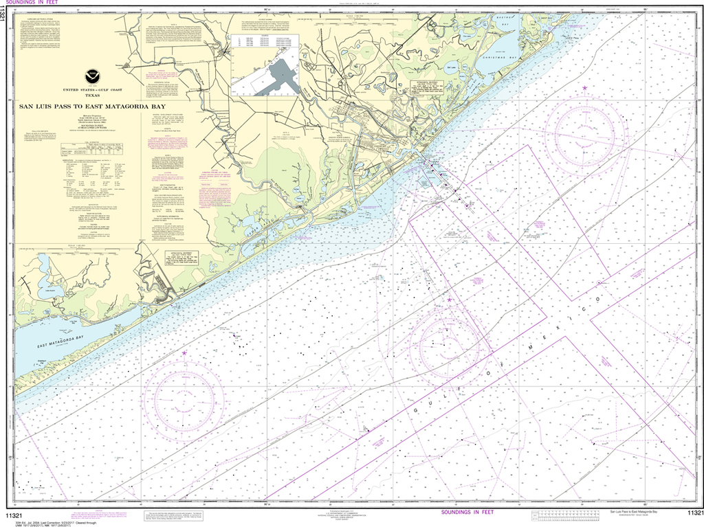
NOAA Chart 11321: San Luis Pass to East Matagorda Bay
$23.75
Region: Gulf Coast & Caribbean Islands Paper Size: 48" x 36" Chart Image Size: 34" x 45" Scale: 1:80,000 Captain's Nautical Supplies is a Print-on-Demand nautical chart dealer for US Waters. All charts are printed up-to-date and corrected to...
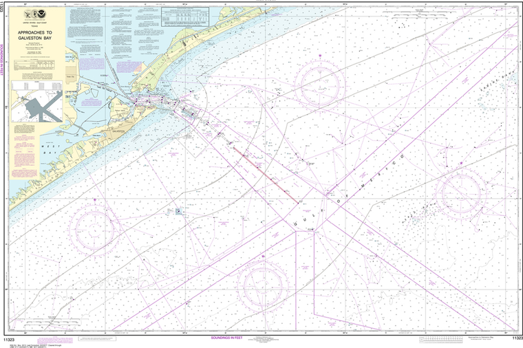
The chart you are viewing is NOT updated weekly and does NOT include all of the latest Notice to Mariners corrections. Region: Gulf Coast & Caribbean Islands Paper Size: 56" x 36" Chart Image Size: 35" x 52" Scale:...
The chart you are viewing is NOT updated weekly and does NOT include all of the latest Notice to Mariners corrections. Region: Gulf Coast & Caribbean Islands Paper Size: 62" x 36" Chart Image Size: 58" x 32" Scale:...
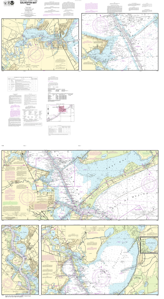
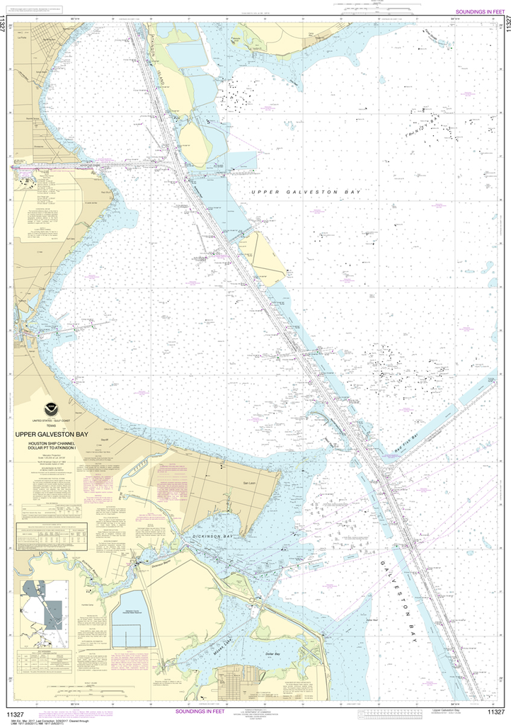
NOAA Chart 11327: Upper Galveston Bay, Houston Ship Channel, Dollar Point to Atkinson
$23.75
The chart you are viewing is NOT updated weekly and does NOT include all the of the latest Notice to Mariners corrections. Region: Gulf Coast & Caribbean Islands Paper Size: 52" x 36" Chart Image Size: 48" x...
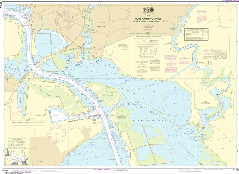
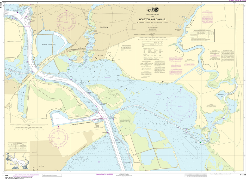
NOAA Chart 11328: Houston Ship Channel Atkinson Island to Alexander Island
$23.75
The chart you are viewing is NOT updated weekly and does NOT include all of the latest Notice to Mariners corrections. Region: Gulf Coast & Caribbean Islands Paper Size: 51" x 36" Chart Image Size: 35" x 48" Scale: 1:10,000...
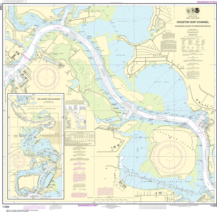
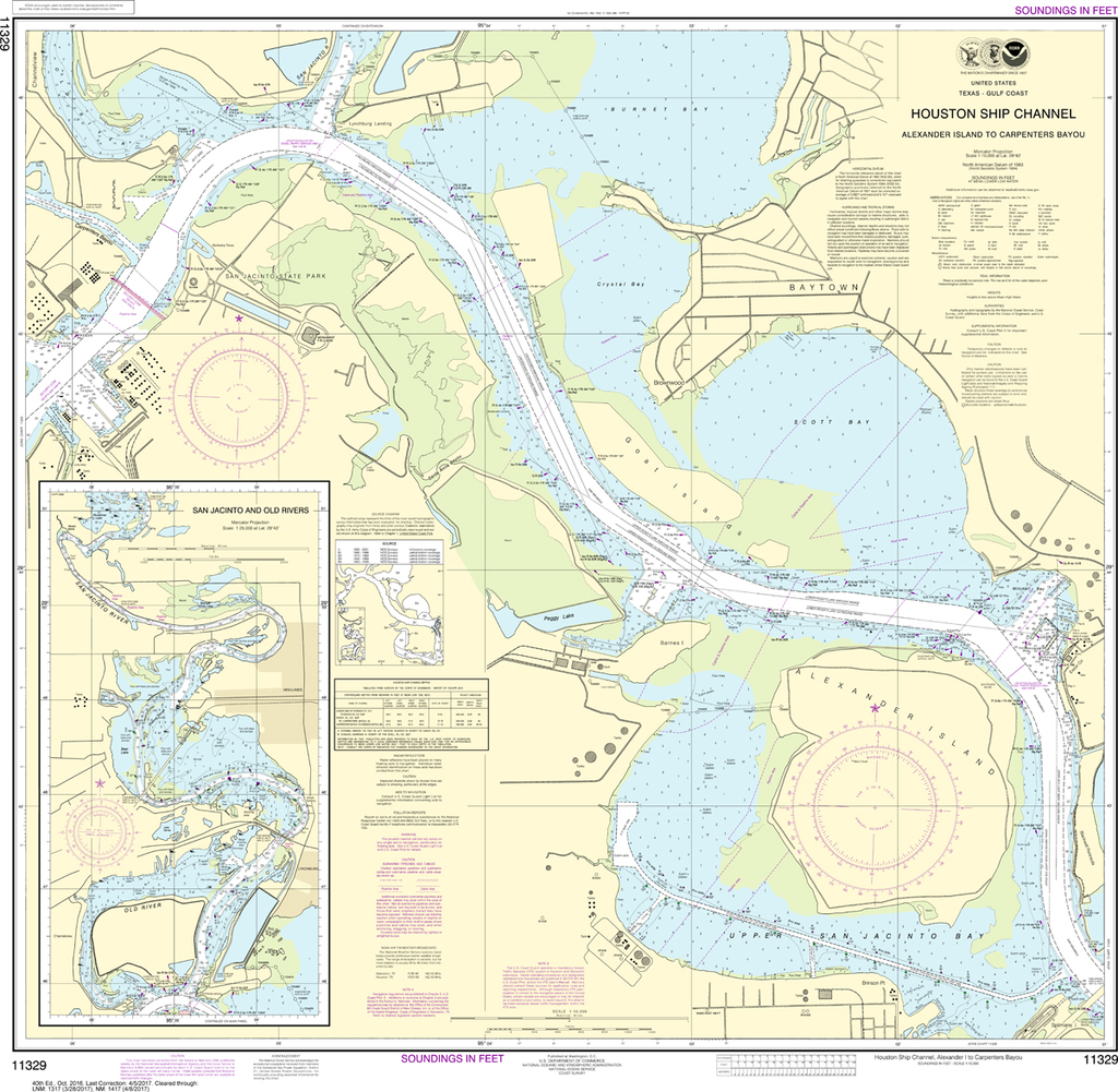
NOAA Chart 11329: Houston Ship Channel Alexander Island to Carpenters Bayou, San Jacinto and Old Rivers
$23.75
Region: Gulf Coast & Caribbean Islands Paper Size: 37" x 36" Chart Image Size: 34" x 34" Scale: 1:25,000 Captain's Nautical Supplies is a Print-on-Demand nautical chart dealer for US Waters. All charts are printed up-to-date and corrected...
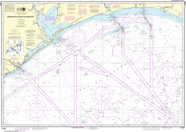
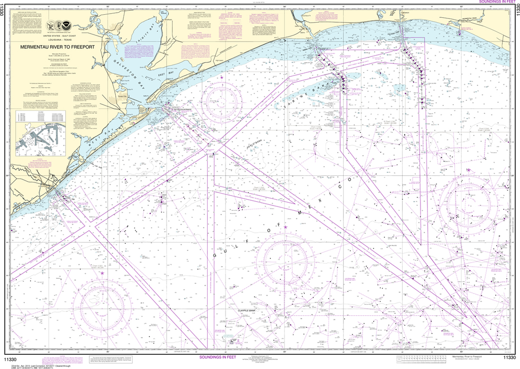
The chart you are viewing is NOT updated weekly and does NOT include all the of the latest Notice to Mariners corrections. Region: Gulf Coast & Caribbean Islands Paper Size: 49" x 36" Chart Image Size: 32" x 45"...
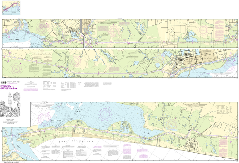
NOAA Chart 11331: Intracoastal Waterway - Ellender to Galveston Bay
$23.75
The chart you are viewing is NOT updated weekly and does NOT include all of the latest Notice to Mariners corrections. Region: Gulf Coast & Caribbean Islands Paper Size: 62" x 42" Chart Image Size: 40" x 59" Scale:...
The chart you are viewing is NOT updated weekly and does NOT include all the of the latest Notice to Mariners corrections. Region: Gulf Coast & Caribbean Islands Paper Size: 48" x 36" Chart Image Size: 33" x 44"...
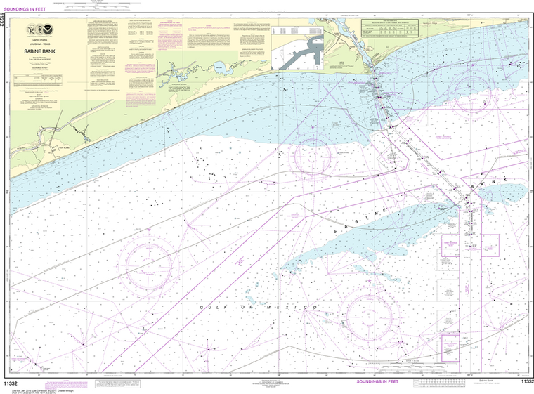
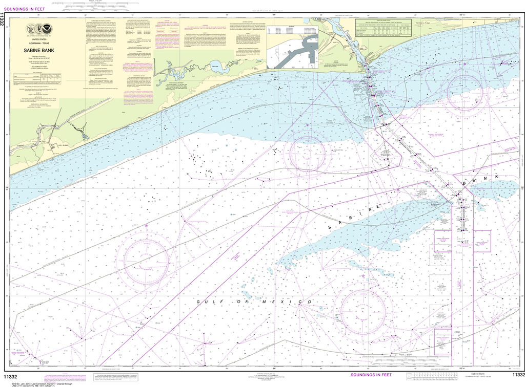
Region: Gulf Coast & Caribbean Islands Paper Size: 61" x 36" Chart Image Size: 57" x 34" Scale: 1:50,000 Captain's Nautical Supplies is a Print-on-Demand nautical chart dealer for US Waters. All charts are printed up-to-date and...
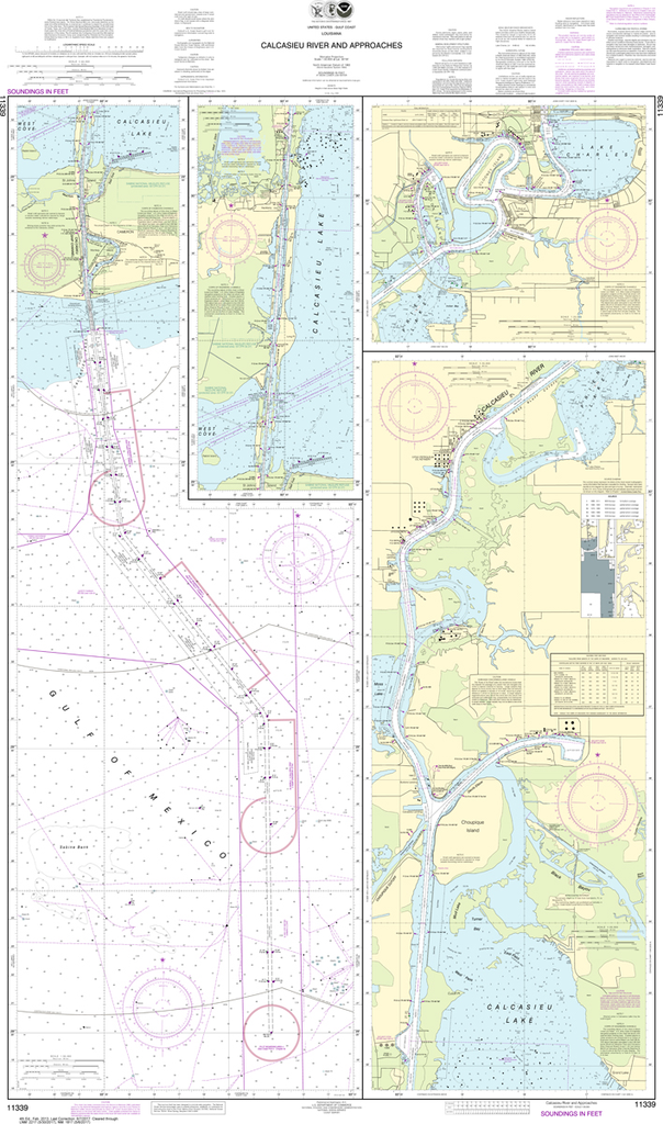
The chart you are viewing is NOT updated weekly and does NOT include all the of the latest Notice to Mariners corrections. Region: Gulf Coast & Caribbean Islands Paper Size: 52" x 36" Chart Image Size: 35" x 48"...