Region: Gulf Coast & Caribbean Islands Paper Size: 51" x 36" Chart Image Size: 47" x 34" Scale: 1:80,000 Captain's Nautical Supplies is a Print-on-Demand nautical chart dealer for US Waters. All charts are printed up-to-date and corrected to...
NOAA Chart 11411: Intracoastal Waterway - Tampa Bay to Port Richey
$23.75
The chart you are viewing is NOT updated weekly and does NOT include all of the latest Notice to Mariners corrections. Region: Gulf Coast & Caribbean Islands Paper Size: 62" x 42" Chart Image Size: 41" x 58" Scale:...
Region: Gulf Coast & Caribbean Islands Paper Size: 45" x 36" Chart Image Size: 42" x 34" Scale: 1:80,000 Captain's Nautical Supplies is a Print-on-Demand nautical chart dealer for US Waters. All charts are printed up-to-date and corrected to...
NOAA Chart 11415: Tampa Bay Entrance, Manatee River Extension
$23.75
The chart you are viewing is NOT updated weekly and does NOT include all of the latest Notice to Mariners corrections. Region: Gulf Coast & Caribbean Islands Paper Size: 53" x 36" Chart Image Size: 35" x 50" Scale:...
NOAA Chart 11416: Tampa Bay, Safety Harbor, St. Petersburg, Tampa
$23.75
The chart you are viewing is NOT updated weekly and does NOT include all of the latest Notice to Mariners corrections. Region: Gulf Coast & Caribbean Islands Paper Size: 54" x 36" Chart Image Size: 51" x 34" Scale:...
The chart you are viewing is NOT updated weekly and does NOT include all the of the latest Notice to Mariners corrections. Region: Gulf Coast & Caribbean Islands Paper Size: 48" x 36" Chart Image Size: 45" x 30"...
Region: Gulf Coast & Caribbean Islands Paper Size: 47" x 36" Chart Image Size: 44" x 33" Scale: 1:80,000 Captain's Nautical Supplies is a Print-on-Demand nautical chart dealer for US Waters. All charts are printed up-to-date and corrected to...
NOAA Chart 11425: Intracoastal Waterway - Charlotte Harbor to Tampa Bay
$23.75
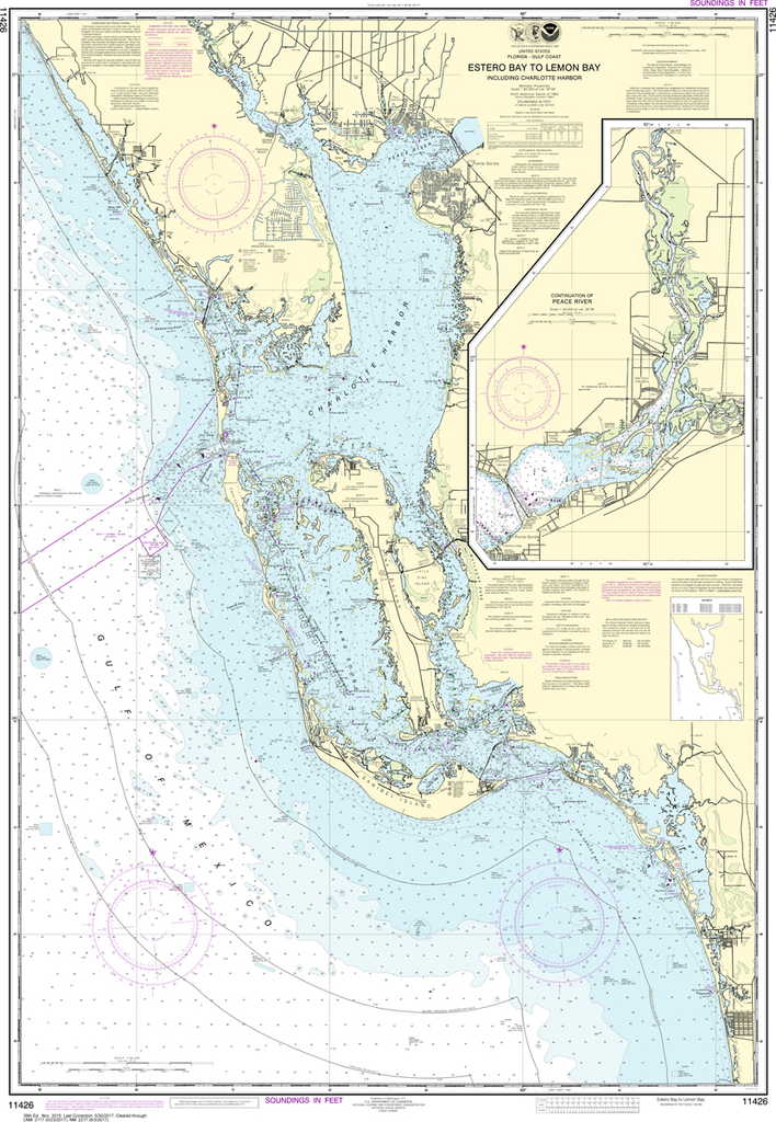
The chart you are viewing is NOT updated weekly and does NOT include all of the latest Notice to Mariners corrections. Region: Gulf Coast & Caribbean Islands Paper Size: 62" x 42" Chart Image Size: 40" x 59" Scale:...
NOAA Chart 11426: Estero Bay to Lemon Bay, including Charlotte Harbor; Continuation of Peace River
$23.75
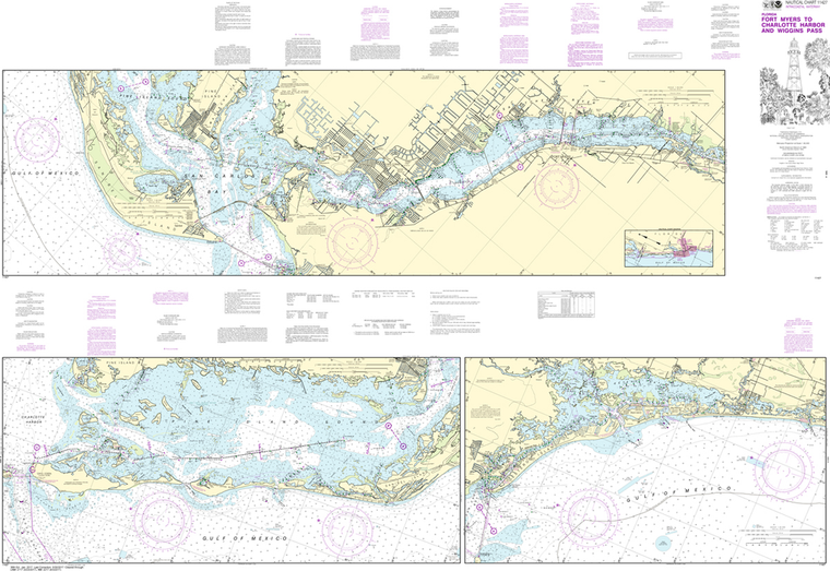
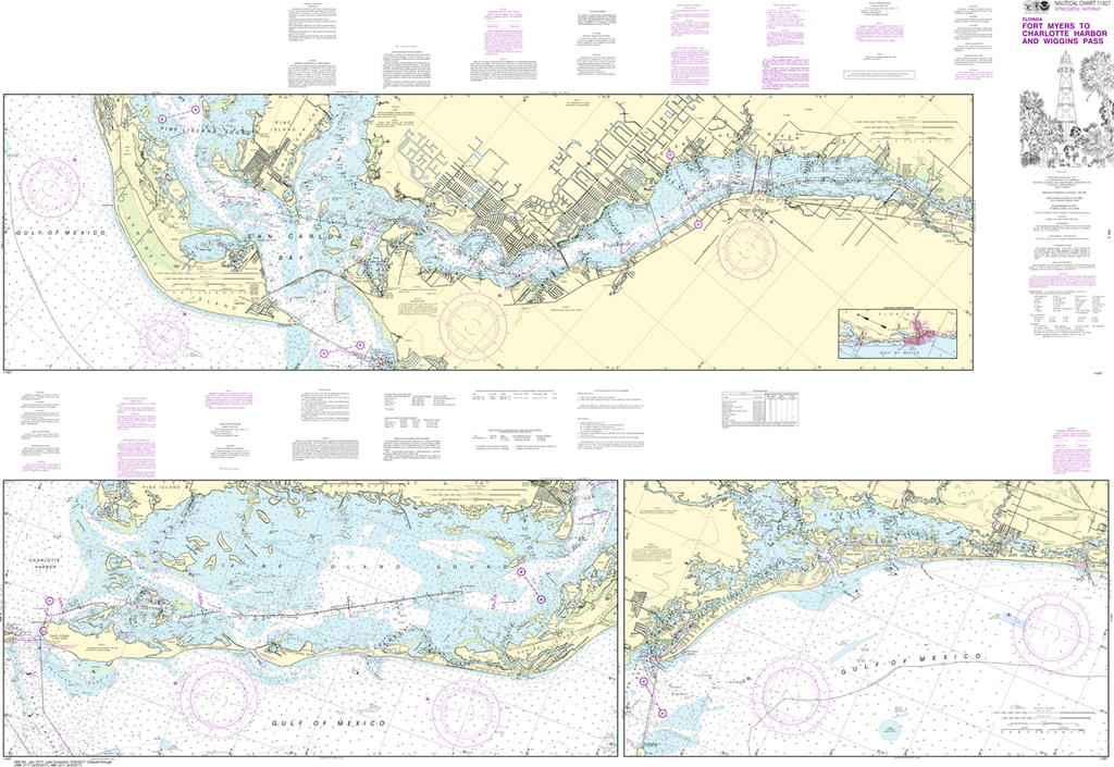
Region: Mid-Atlantic Paper Size: 51" x 36" Chart Image Size: 48" x 33" Scale: 1:80,000 Captain's Nautical Supplies is a Print-on-Demand nautical chart dealer for US Waters. All charts are printed up-to-date and corrected to the latest Notice to...
NOAA Chart 11427: Intracoastal Waterway - Fort Myers to Charlotte Harbor and Wiggins Pass
$23.75
The chart you are viewing is NOT updated weekly and does NOT include all of the latest Notice to Mariners corrections.
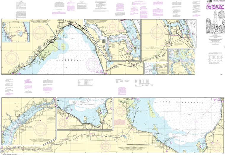
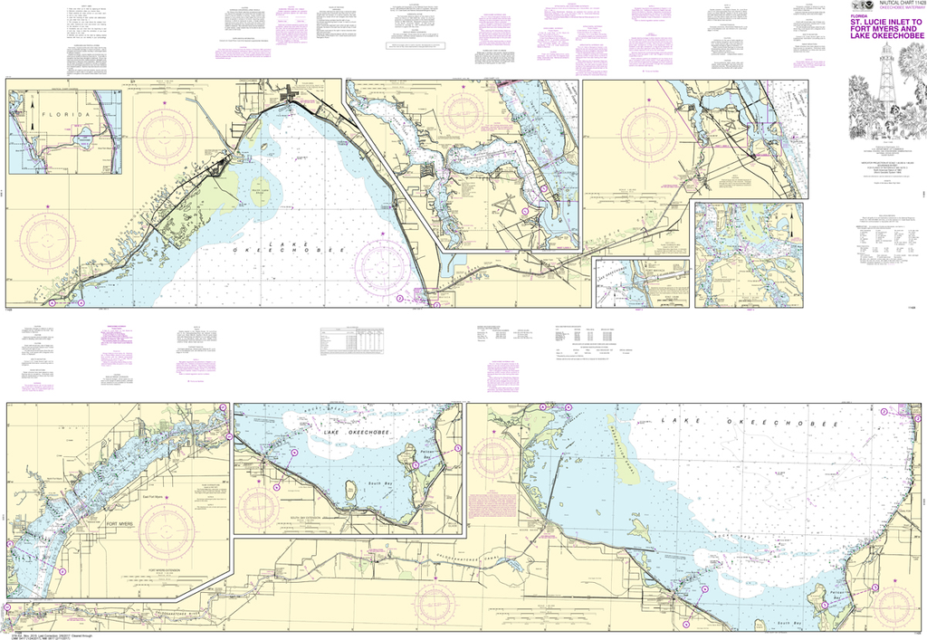
Region: Mid-Atlantic Paper Size: 62" x 42" Chart Image Size: 41" x 59" Scale: 1:40,000
NOAA Chart 11428: Okeechobee Waterway St. Lucie Inlet to Fort Myers, Lake Okeechobee
$23.75
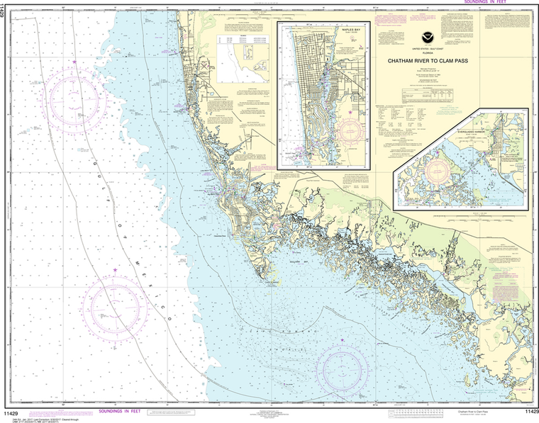
Region: Mid-Atlantic Paper Size: 62" x 42" Chart Image Size: 41" x 59" Scale: 1:40,000 Captain's Nautical Supplies is a Print-on-Demand nautical chart dealer for US Waters. All charts are printed up-to-date and corrected to the latest Notice to...
NOAA Chart 11429: Chatham River to Clam Pass, Naples Bay, Everglades Harbor
$23.75
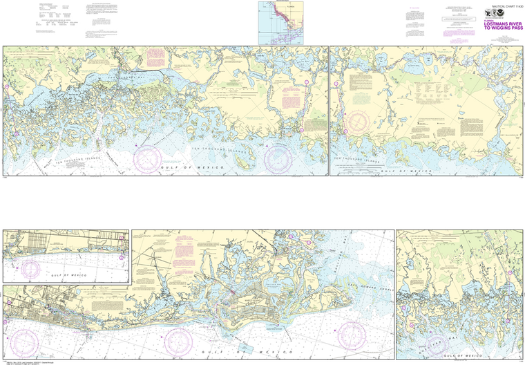
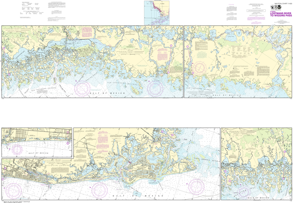
Region: Mid-Atlantic Paper Size: 46" x 36" Chart Image Size: 33" x 42" Scale: 1:80,000 Captain's Nautical Supplies is a Print-on-Demand nautical chart dealer for US Waters. All charts are printed up-to-date and corrected to the latest Notice to...
The chart you are viewing is NOT updated weekly and does NOT include all of the latest Notice to Mariners corrections.
Region: Mid-Atlantic Paper Size: 62" x 42" Chart Image Size: 41" x 59" Scale: 1:40,000
Region: Gulf Coast & Caribbean Islands Paper Size: 49" x 36" Chart Image Size: 46" x 34" Scale: 1:80,000 Captain's Nautical Supplies is a Print-on-Demand nautical chart dealer for US Waters. All charts are printed up-to-date and corrected...
NOAA Chart 11432: Everglades National Park - Shark River to Lostmans River
$23.75
Region: Gulf Coast & Caribbean Islands Paper Size: 44" x 36" Chart Image Size: 29" x 41" Scale: 1:50,000 Captain's Nautical Supplies is a Print-on-Demand nautical chart dealer for US Waters. All charts are printed up-to-date and corrected to...
NOAA Chart 11433: Everglades National Park -Whitewater Bay
$23.75
Region: Gulf Coast & Caribbean Islands Paper Size: 44" x 36" Chart Image Size: 31" x 40" Scale: 1:50,000 Captain's Nautical Supplies is a Print-on-Demand nautical chart dealer for US Waters. All charts are printed up-to-date and corrected to...
Region: Gulf Coast & Caribbean Islands Paper Size: 33" x 36" Chart Image Size: 30" x 35" Scale: 1:30,000 Captain's Nautical Supplies is a Print-on-Demand nautical chart dealer for US Waters. All charts are printed up-to-date...
Region: Gulf Coast & Caribbean Islands Paper Size: 45" x 36" Chart Image Size: 35" x 41" Scale: 1:80,000 Captain's Nautical Supplies is a Print-on-Demand nautical chart dealer for US Waters. All charts are printed up-to-date and corrected to...
The chart you are viewing is NOT updated weekly and does NOT include all of the latest Notice to Mariners corrections. Region: Gulf Coast & Caribbean Islands Paper Size: 47" x 36" Chart Image Size: 35" x 44" Scale:...
Region: Gulf Coast & Caribbean Islands Paper Size: 49" x 36" Chart Image Size: 35" x 46" Scale: 1:80,000 Captain's Nautical Supplies is a Print-on-Demand nautical chart dealer for US Waters. All charts are printed up-to-date and corrected to...
Region: Gulf Coast & Caribbean Islands Paper Size: 41" x 36" Chart Image Size: 27" x 38" Scale: 1:40,000 Captain's Nautical Supplies is a Print-on-Demand nautical chart dealer for US Waters. All charts are printed up-to-date and corrected to...
NOAA Chart 11446: Intracoastal Waterway - Sugarloaf Key To Key West
$23.75
The chart you are viewing is NOT updated weekly and does NOT include all of the latest Notice to Mariners corrections. Region: Gulf Coast & Caribbean Islands Paper Size: 41" x 36" Chart Image Size: 30" x 38" Scale:...
The chart you are viewing is NOT updated weekly and does NOT include all of the latest Notice to Mariners corrections. Region: Gulf Coast & Caribbean Islands Paper Size: 46" x 36" Chart Image Size: 42" x 35" Scale:...
NOAA Chart 11448: Intracoastal Waterway - Big Spanish Channel to Johnston Key
$23.75
Region: Gulf Coast & Caribbean Islands Paper Size: 42" x 36" Chart Image Size: 28" x 38" Scale: 1:40,000 Captain's Nautical Supplies is a Print-on-Demand nautical chart dealer for US Waters. All charts are printed up-to-date and corrected to...